"650-Foot Mega-Tsunami Triggers 9-Day Sustained Seismic Activity, Scientists Confirm"
Mysterious 2023 Seismic Event Solved: Greenland Mega-Tsunami Shook Earth for 9 Days
(Images: Satellite view of Dickson Fjord; collapsed mountain; SWOT satellite illustration; damaged Ella Island station; Swiss village destruction)
In September 2023, scientists detected bizarre seismic waves pulsing every 90 seconds for nine days. Nearly two years later, researchers from the University of Oxford have pinpointed the cause: a 650-foot (200-meter) mega-tsunami triggered by a massive landslide in Greenland.
The Collapse That Started It All
A 3,937-foot (1,200-meter) mountain collapsed into Greenland’s remote Dickson Fjord, releasing 25 million cubic meters of rock and ice. The impact generated a colossal wave that ricocheted within the fjord as a “seiche”—a standing wave trapped in an enclosed body of water.
Lead researcher Thomas Monahan described the seiche as a 7.9-meter (26-foot) wall of water exerting 500 Giga Newtons of force—equivalent to 14 Saturn V rocket launches. This force vibrated Earth’s crust repeatedly, explaining the mysterious seismic signals.
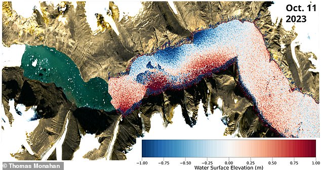
(Image: Satellite imagery showing the landslide scar and debris field in Dickson Fjord)
Why Did the Tsunami Go Unnoticed?
Despite its power, the tsunami remained undetected by a Danish military vessel visiting days later. The wave rapidly diminished from 23 feet (7 meters) to mere centimeters in height as it oscillated across the 6.2-mile (10 km) fjord. Without understanding what to look for, observers missed the subtle remnants.
Satellite Breakthrough Solves the Mystery
Using data from NASA’s Surface Water Ocean Topography (SWOT) satellite—launched in 2022—researchers captured the first direct evidence of the seiche. SWOT’s twin antennas provide centimeter-level accuracy, mapping 90% of Earth’s water surfaces.
(Image: Artist’s rendition of the SWOT satellite in orbit)
Monahan explained: “SWOT’s 2D height measurements revealed the water slope during the seiche.” Combined with seismic records and environmental data, the team confirmed the tsunami originated from the landslide, ruling out weather or tides.
Climate Change’s Role in Freak Events
The landslide was likely fueled by glacial weakening due to global warming, according to University College London research. Greenland’s melting glaciers destabilize mountains, increasing landslide risks. Had a cruise ship been in Dickson Fjord, the tsunami could have been catastrophic.
(Image: Before/after photos of melting glaciers near Greenland’s fjords)
A Warning for the Future
Similar disasters are rising globally. In May 2025, Switzerland’s Birch Glacier collapse unleashed a nine-million-ton debris cone, destroying 90% of Blatten village. Rising temperatures threaten more remote regions, where monitoring remains scarce.
(Image: Satellite view of Swiss village buried under glacial debris)
Why This Matters
The study, published in Nature Communications, highlights how cutting-edge satellites like SWOT can decode previously invisible hazards. As climate change accelerates extreme events, such technologies are vital for early warnings and mitigating risks.
(Image: Infographic comparing tsunami force to rocket launches)
TL;DR
- A 2023 seismic mystery was caused by a Greenland landslide-turned-mega-tsunami.
- Satellite tech revealed a trapped “seiche” wave with the force of 14 rockets.
- Climate change is increasing landslide risks, threatening coastal and mountain regions.
- New satellites are critical for tracking hidden disasters in a warming world.
(Image: Global map highlighting areas at risk from glacial collapses)
This discovery underscores the urgent need for advanced monitoring as climate-driven extremes reshape our planet’s geology.


