U.S. Drinking Water Arsenic Contamination Map Reveals Hidden Risk: Is Your Area Affected?
Alarming Arsenic Hotspots in U.S. Drinking Water Revealed (Approx. 600 words)
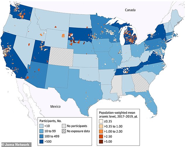
A new study has uncovered widespread arsenic contamination in U.S. drinking water, exposing millions to potential health risks. Researchers from Columbia University mapped arsenic levels using EPA data (2017–2019) and identified hazardous hotspots across multiple states, including Michigan, California, New York, Texas, and the Southwest (see Map 1). Arsenic, a toxic element found naturally in soil and rock, seeps into groundwater and can cause cancer, cardiovascular disease, and developmental issues even at low concentrations.
Key Findings:
- Danger Zones: Areas in Michigan’s Lower Peninsula, California’s Central Valley, parts of the Midwest, and the Southwest exceed 5 micrograms per liter (µg/L), a hazardous threshold (Map 1). The World Health Organization (WHO) advises a maximum of 10 µg/L, but studies show risks emerge at lower levels.
- Moderate Risks: Regions in Ohio, Indiana, Missouri, Colorado, and other states showed moderate arsenic levels (1.0–5.0 µg/L). Rural and low-income communities are disproportionately affected, often lacking resources to address contamination (Map 2).
- Root Causes: Industrial activity, agriculture, and natural geology drive contamination. Michigan’s Thumb region and Oakland County, for example, face high arsenic due to industrial runoff and arsenic-rich bedrock. New York’s Binghamton area has similar issues from glacial deposits.
Health Impacts:
A 2023 Columbia University study linked long-term arsenic exposure to a 42% higher risk of heart disease. Dr. Tiffany Sanchez, the lead researcher, urged reevaluating federal water safety standards, stating, “Our results encourage a renewed discussion of current policy.” Over 2 million Americans may face arsenic exposure, though not always exceeding EPA limits.
Solutions and Awareness:
- Filtration: Most standard filters (e.g., Brita) don’t remove arsenic. Effective options include reverse osmosis systems or activated alumina filters.
- Monitoring: Private wells, common in rural areas, are unregulated. The USGS estimates high arsenic levels in many (Map 3), urging regular testing.
Conclusion:
This map underscores urgent gaps in water safety, particularly for vulnerable populations. Addressing these risks requires policy updates, infrastructure investment, and public education to ensure safer drinking water nationwide.
Suggested Image Placements:
-
Map 1: Hotspots in California’s Central Valley, Midwest, and Southwest.
Caption: Arsenic levels exceed 5 µg/L in these regions, posing significant health risks. -
Map 2: Rural and low-income areas with chronic contamination.
Caption: Disproportionate arsenic exposure in underserved communities. - Map 3: USGS estimate of arsenic in private wells.
Caption: Naturally occurring arsenic in groundwater affects many unregulated wells.
(Word count: ~600)


