Antarctic Ice Sheet Hides Unexpected Subterranean Structures, Scientists Reveal
Scientists Discover Ancient Flat Landscapes Beneath Antarctica’s Ice
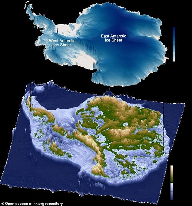
Image: Antarctic topography map
Caption: Researchers mapped 31 flat surfaces beneath the East Antarctic Ice Sheet, shown in green.
Hidden beneath Antarctica’s thick ice sheets for 34 million years, researchers have uncovered a surprising landscape: vast, flat plains stretching over 3,500 km along East Antarctica’s coastline. Using radio-echo sounding technology, scientists revealed these "remarkably" smooth surfaces, formed by ancient river systems after Australia and Antarctica split 80 million years ago. These regions, now buried under ice, are intersected by deep trenches that channel fast-moving glaciers.
A Geological Mystery
The study, published in Nature Geoscience, suggests these surfaces acted as a preglacial river delta system. Slow-moving ice above them may regulate ice loss, critical as East Antarctica holds enough ice to raise global sea levels by 52 meters if melted. Lead author Dr. Guy Paxman (Durham University) noted, “These flat surfaces started to pop out everywhere we looked… They’ve survived 30 million years, preserved rather than eroded by ice.”
Image: Crevassed ice in Princess Elizabeth Land
Caption: The flat surfaces lie under 40% of East Antarctica’s coastline, influencing ice flow.
Implications for Climate Science
The flat terrain covers 40% of East Antarctica’s coast between Princess Elizabeth Land and George V Land. Understanding their role could refine climate models. “They help us predict how ice sheets might respond to warming,” said co-author Prof. Neil Ross (Newcastle University). Researchers plan to drill through the ice to analyze rock samples, revealing when these areas were last ice-free.
Mysterious Radio Signals Detected
In a separate study, the Antarctic Impulsive Transient Antenna (ANITA) detected unexplained radio waves emerging from the ice at steep angles. These signals, detailed in Physical Review Letters, defy current particle physics understanding, hinting at unknown particles or dark matter. “We still don’t have an explanation,” said astrophysicist Dr. Stephanie Wissel.
Image: Continental drift map
Caption: Antarctica’s flat surfaces (red) formed after breaking from Australia and India 80 million years ago.
Antarctica’s Critical Role in Sea Levels
Antarctica’s ice sheets hold 70% of Earth’s freshwater. If fully melted, global sea levels would rise ~180 feet (56 meters). Even partial melting could disrupt ocean currents and weather patterns, underscoring the urgency of understanding these hidden landscapes.
Image: Bunger Hills
Caption: Bunger Hills, an exposed fragment of Antarctica’s ancient flat terrain.
By integrating geological history with modern technology, scientists aim to unravel how Antarctica’s past shapes its future—and ours.


