Bizarre Weather Pattern Leaves California Shivering Through Unseasonably Cold Summer
California’s Unusually Cool Summer: Marine Layer and Jet Stream Keep Skies Gray
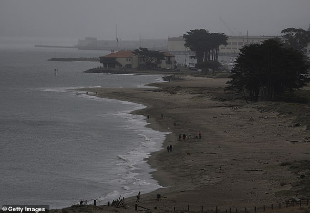
[Image: Dense fog blankets California’s coastline, with low-hanging clouds obscuring the sun.]
California is experiencing its coldest summer since 1965, with Bay Area temperatures averaging 67°F—4 degrees below the usual 71°F. The culprit? A stubborn marine layer, a dense blanket of cool, moist air from the Pacific Ocean that traps clouds near the coast. Known for creating “June Gloom” or “No-Sky July,” this phenomenon has lingered longer than normal, dampening beach days and leaving residents bundled up.
Why the Marine Layer Is Sticking Around
The marine layer forms when warm, dry air meets cold ocean water. This summer, colder-than-average waters off Baja California intensified the effect. “Upper-level low-pressure systems have enhanced the marine layer, making low clouds more persistent,” explains AccuWeather’s Chad Merrill. San Francisco saw highs 5°F cooler than average, with overcast skies dominating mornings.
[Image: Diagram showing warm air colliding with cool Pacific waters, creating a dense marine layer.]
Unlike the East Coast—where warm Gulf Stream waters prevent such layers—California’s cold Pacific currents from Alaska allow the marine layer to linger for weeks. “The onshore flow from upper-level lows has locked in cool conditions,” Merrill adds.
From ‘May Gray’ to ‘No-Sky July’
Locals joke about the season’s nicknames, but the impact is real. The San Francisco Chronicle’s Greg Porter notes that even inland areas, typically hotter, stayed below 80°F this July. Coastal regions faced highs in the 60s, while inland valleys saw dramatic swings: 60s at the shore vs. 90s just 20 miles away.
[Image: Tourists in jackets at San Francisco’s foggy Pier 39, gazing at a shrouded Alcatraz Island.]
The Jet Stream’s Role
A stagnant jet stream worsened the gloom. These high-altitude winds usually push weather systems eastward, but this summer, they stalled. “California remains on the eastern edge of a high-pressure ridge, locking in cool air,” says Porter. Meanwhile, the same pattern fueled heatwaves in Europe and floods in the U.S. Midwest.
When Will the Sun Return?
Forecasters expect gray skies through August. “Cold sea temperatures will keep marine layers thick and slow daytime warming,” Porter warns. While Californians wait for sunshine, other states face extremes: Texas saw deadly floods, and the Northeast baked under 100°F heat.
[Image: Satellite map showing the stationary jet stream pattern over the western U.S.]
For now, the Golden State’s summer charm remains under clouds, proving that even sun-drenched coasts aren’t immune to nature’s whims.
(Word count: ~600)


