Iceland Volcano’s Imminent Eruption Revealed Through Eerie Seismic Audio Clues
Iceland Volcano Erupts, Triggering Evacuations and Seismic Alarms
[Image: Aerial view of the eruption near Grindavík, showing lava flowing through a fissure. Caption: A 1,200-meter fissure erupted on Iceland’s Reykjanes Peninsula, sending lava toward Grindavík and the Blue Lagoon.]
Iceland’s Reykjanes Peninsula volcano erupted Tuesday, spewing lava through defensive barriers and forcing evacuations in Grindavík and the Blue Lagoon resort. The eruption followed a 48-hour “earthquake swarm” detected by scientists, signaling magma movement beneath the surface.
Earthquake Swarm Warns of Eruption
The Iceland Meteorological Office (IMO) reported over 1,400 earthquakes in 48 hours, including a magnitude 5.3 tremor felt across southwest Iceland. Using the Earthtunes app—which converts seismic data into sound—researchers captured eerie rumbles and knocks preceding the eruption. The app’s audio revealed escalating activity starting at 6:30 AM local time, culminating in the fissure opening at 9:45 AM.
[Image: Screenshot of the Earthtunes app interface. Caption: The Earthtunes app translates seismic waves into audio, capturing earthquake swarms and volcanic activity.]
Lava Breaches Defenses, Threatens Infrastructure
The initial fissure stretched 1,200 meters, with a second crack opening inside Grindavík’s protective barriers. Lava damaged a hot water pipeline, confirming significant ground shifts. Volcanologist Valentin Troll noted “clinking” sounds in recordings, likely from falling debris. Despite slowed lava flow, earthquakes persisted, including a magnitude 5.2 quake near Grindavík.
[Image: Map of Reykjanes Peninsula earthquakes. Caption: Three major quakes struck near Grindavík, including a magnitude 5.2 event (orange dots).]
Risks to Critical Highways
Experts warn seismic activity is migrating north, endangering Highway 41, which connects Reykjavík to Keflavík International Airport. “An eruption here could sever Iceland’s main supply route,” said Troll. Authorities are preparing alternate transport plans, including expanding Reykjavík’s domestic airport.
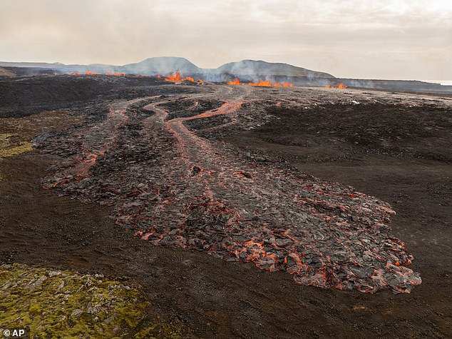
[Image: Lava encroaching near Grindavík. Caption: Lava from the Sundhnúkur crater row threatens evacuated areas, with experts warning of larger eruptions.]
Why Iceland? The Mid-Atlantic Ridge
Iceland sits atop the Mid-Atlantic Ridge, where tectonic plates diverge, allowing magma to rise. This geological hotspot has fueled eight eruptions since 2021.
[Image: Diagram of tectonic plates. Caption: Iceland’s location on the Mid-Atlantic Ridge makes it prone to volcanic activity.]
Ongoing Threats
Grindavík, evacuated in 2023, remains a ghost town, with most residents relocating. Officials urge holdouts to leave as risks persist. Previous eruptions have reshaped the region, and scientists predict continued instability.
How Scientists Predict Eruptions
Key indicators include:
- Seismic activity: Increased earthquakes signal magma movement.
- Gas emissions: Rising sulfur dioxide levels indicate magma nearing the surface.
- Ground deformation: Swelling or cracking suggests underground pressure changes.
[Image: Scientists monitoring equipment. Caption: Researchers use gas sensors and seismographs to predict volcanic activity.]
As Iceland braces for potential new fissures, the world watches a stark reminder of nature’s power.
Word count: 598


