Mapping Deadly Texas Flash Floods: Impact Zones Linked to 100+ Deaths
Deadly Texas Floods Leave Over 100 Dead, Dozens Missing
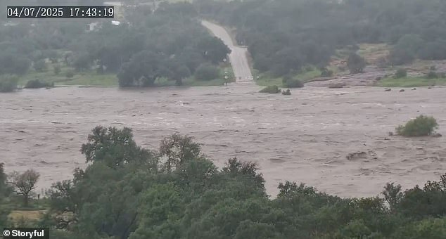
[Image: A raging Guadalupe River submerges vehicles and buildings]
Caption: The Guadalupe River swelled 30 feet in 45 minutes, overwhelming communities.
At least 104 people are confirmed dead in Texas after catastrophic flash floods struck during Fourth of July weekend, with the hardest-hit areas near San Antonio. Kendall County reported six deaths, while over 20 individuals remain missing. Rescue teams continue searching submerged regions as the National Weather Service (NWS) warns of ongoing thunderstorms and up to 5 inches of additional rain, exacerbating flood risks.
Rapid River Surges Cause Unprecedented Damage
The Guadalupe River’s historic rise—reaching 39 feet in under three hours—triggered the most severe destruction, marking the worst flooding since 1987. The river’s torrents swept through towns like Kerrville and Comfort, engulfing neighborhoods and infrastructure up to seven miles inland. Satellite maps reveal a 150-mile flood footprint across river corridors, impacting 2,000 square miles. The San Gabriel, San Saba, Pedernales, and Llano rivers also overflowed, with floodwaters spanning up to five miles inland in rural areas.
[Image: Aerial view of submerged homes in Kerr County]
Caption: Entire neighborhoods in Kerr County vanished underwater.
Summer Camp Tragedy
Camp Mystic, a Christian girls’ camp in Hunt, became a symbol of the disaster. Flash floods swept away the Bubble Inn cabin, killing 10 campers and counselor Chloe Childress. Three campers and counselor Katherine Ferruzzo are still missing. Families gathered at the George W. Bush Presidential Center for a vigil, honoring traditions of the 94-year-old camp.
Climate Change Intensifies Threats
Scientists link the floods to climate-driven weather extremes, noting that warmer air holds more moisture, leading to heavier rains. Similar risks loom for states like Florida, Louisiana, and the Carolinas due to low elevations, dense urbanization, or mountainous terrain. New York and New Jersey also face vulnerabilities from rapid runoff and inadequate drainage systems.
[Image: Rescue teams in boats navigate flooded streets]
Caption: Emergency crews search for survivors in Williamson County.
Ongoing Risks
With flood alerts active across central Texas, officials urge vigilance. NWS emphasized that even moderate rain could trigger new flooding, particularly in waterlogged regions. The disaster underscores the urgent need for improved infrastructure and climate adaptation strategies as extreme weather becomes more frequent.
[Image: Map highlighting flood-affected Texas regions]
Caption: Over 2,000 square miles were inundated, with recovery expected to take months.
As Texas mourns, the nation faces a stark reminder of nature’s power—and the growing urgency of preparedness in an era of climate crisis.


