Understanding the Roll Cloud: Experts Decipher Portugal’s Tsunami-Like Sky Wall Phenomenon
Bizarre ‘Roll Cloud’ Stuns Beachgoers in Portugal, Explained by Experts
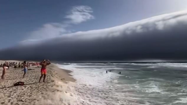
Beachgoers in Portugal were startled this week by a dramatic, tsunami-like cloud formation rolling toward shore. Viral social media footage showed a massive horizontal wall of clouds advancing from the horizon, accompanied by strong winds as it reached land.

The ominous cloud triggered comparisons to disaster movies.
While some panicked observers compared it to a tsunami, meteorologists identified the phenomenon as a rare roll cloud (or arcus cloud)—a tubular, low-level cloud formation linked to thunderstorms.
What Are Roll Clouds?
Roll clouds are a type of arcus cloud, forming as a horizontal cylinder separate from storm systems. Unlike shelf clouds (which attach to thunderstorms), roll clouds appear detached, creating their signature "rolling" effect.
How Do They Form?
Roll clouds develop when cold air from a storm downdraft pushes warm, moist air upward. As the rising air cools, water vapor condenses into the distinct cloud structure. Wind variations at different altitudes can make the cloud rotate.

The cloud formed during a heatwave with record-breaking 46.6°C temperatures.
The Met Office explains: “When a cold downdraft spreads along the ground, it lifts warm air, forming these clouds. Differences in wind direction cause the rolling motion.”
Weather Warnings
Roll clouds signal approaching severe weather, including thunderstorms, heavy rain, hail, and strong winds. In Portugal, the spectacle followed days of extreme heat and preceded stormy conditions.
Global Sightings
While rare, roll clouds have appeared worldwide:
- 2018: A massive formation loomed over New Orleans.
- 2019: A timelapse captured a rolling cloud in Ireland.
- 2021: A stunning example emerged off Melbourne, Australia.
Key Facts About Roll Clouds
- Official Name: Classified as volutus in the World Meteorological Organization’s Cloud Atlas.
- Shape: Long, tube-like, and detached from storm bases.
- Formation: Requires a mix of cold downdrafts and rising warm air.

The rare cloud amazed onlookers in southwestern Portugal.
While alarming in appearance, roll clouds remain a fascinating meteorological quirk—not a tsunami, but a reminder of nature’s power.
Read more: Met Office Weather Updates | WMO Cloud Atlas
Published: 14:13 BST, 1 July 2025 | Updated: 14:13 BST, 1 July 2025
Share or comment on this article: Experts decode the ‘roll cloud’ behind Portugal’s tsunami-like spectacle.


